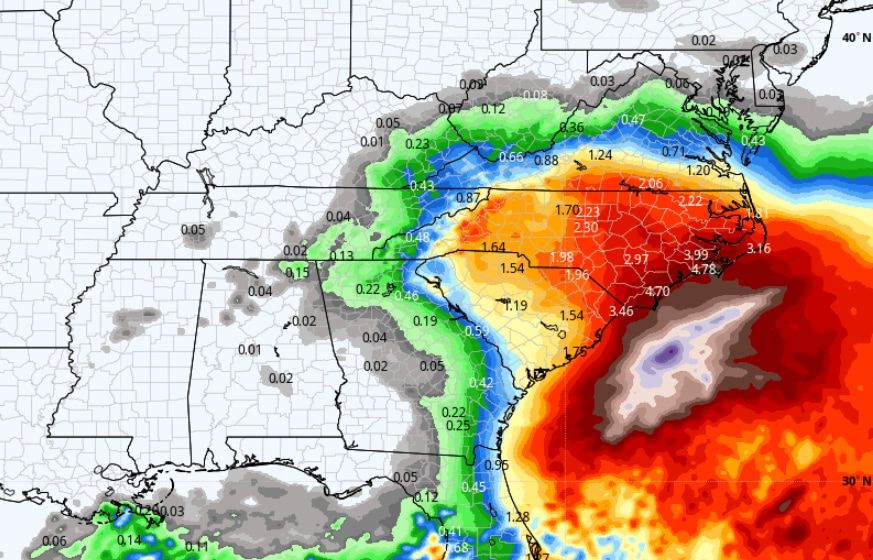
Here’s how a strong Southeast storm could affect Memorial Day weekend
Listen 5 min Comment on this story Comment Gift Article Share
AAA estimates some 37.1 million Americans will travel by road this Memorial Day weekend, and an additional 17 million are expected to take to the skies. Many are anxiously monitoring the holiday weekend weather forecast — and in the Southeast and Mid-Atlantic, a looming storm system could pose some problems. Fast, informative and written just for locals. Get The 7 DMV newsletter in your inbox every weekday morning. ArrowRight A “cutoff low” — a low-pressure system pinched off from the jet stream — will stall over the Southeast, bringing days of unsettled conditions, especially in the Carolinas. In addition to spreading cloud cover over the Southeast, heavy rain, windy conditions along the coast and well below-average temperatures are possibilities.
The system “is likely to produce gusty winds and dangerous surf and rip current conditions along portions of the southeastern United States coast late this week and into the weekend,” the National Hurricane Center wrote Thursday. “Heavy rainfall is expected in portions of the Carolinas, with hazardous marine conditions expected over the coastal and offshore waters where gale warnings are in effect.”
The low-pressure zone will be flanked by a toasty ridge of high pressure which will hover over parts of the Northeast, delivering sunny skies and temperatures 5 to 10 degrees above normal. The overarching weather pattern will probably feature better beach weather in Maine than Myrtle Beach.
A stormy setup for the Carolinas
The cutoff low will act as a big atmospheric mixing bowl. Dry air tugged south on its backside may bring a strip of clear skies into Arkansas, Louisiana, Mississippi and western Tennessee. To the east, however, a filament of robust Gulf of Mexico moisture will be drawn into the system, aimed directly at the Southeast coast.
That moisture fire hose could make for heavy rain east of Interstate 95 in South Carolina on Friday, with downpours lifting north and spreading through North Carolina on Saturday. Colder temperatures, likely only in the 50s to around 60 degrees, will waft south through the Carolinas as northerly winds tug down damp, chilly air from the Piedmont and Appalachians. Even eastern Tennessee may see highs 20 degrees cooler than average.
While Saturday should be a washout in South Carolina, Sunday should feature improvement south to north, with continued downpours in northern North Carolina and Virginia. Across the Carolinas, rainfall totals of 2 to 4 inches are likely, with more possible near the coast.
A tricky call for Northern Virginia, the District and Maryland
For the Richmond to D.C. to Baltimore corridor, it’s still uncertain how much rain, if any, falls. Meteorologists and weather models alike remain torn on which of the two battling systems will win — will the cutoff low and storminess from the south manage to creep north? Or will the pleasant high-pressure zone remain large and in charge?
Advertisement
The American GFS model simulates warmth for the Mid-Atlantic on Saturday, followed by some rain and much cooler weather Sunday and maybe a lingering shower or two Monday.
The European model, conversely, maintains highs in the 70s each of the three days and keeps away most of the rainfall.
The zone from Richmond to Washington is where the uncertainty is greatest. Models depict anything from a soaking rain to nary a drop. For now, it’s simply a game of wait and see.
New England’s toasty high pressure
In New England, highs will climb to the mid-70s Saturday, except around 70 in southeastern Massachusetts and inland Maine. Downeast Maine, Cape Ann and Cape Cod will see highs in the 60s due to their proximity to cooler waters.
By Sunday, highs spike into the 80s in the Connecticut River and Merrimack valleys, as well as the I-95 corridor in Maine. The coastal areas remain characteristically cooler.
A more persistent onshore flow Monday should cool temperatures about 10 degrees everywhere, though sunshine will largely prevail.
The overarching setup
The storm
Advertisement
A broad upper-level low-pressure system, characterized by a pocket of high-altitude cold air, low pressure and spin, will consolidate over Florida within the next 36 hours. It will meander slowly north or northwest, wobbling over Georgia or South Carolina before finally shifting offshore Monday or Tuesday.
Because that cutoff low is detached from the jet stream, is has nothing to scoop it up the coast or move it along. That means it will stall — and pinpointing its exact whereabouts are a challenge.
The high-pressure dome
To the north, meanwhile, the high-pressure dome will become established within a northward crest of the jet stream. It will build over the Great Lakes and Ontario before sauntering east into Quebec by Monday.
The high pressure will bring dry, sinking air and temperatures 15 to 20 degrees above average for some. It will also deflect inclement weather around it and allow sunshine to pour south unencumbered.
Advertisement
A challenging interaction
Complicating forecasts is the fact that these two opposing, and oppositely spinning, weather systems will interact. Like interlocking gears, the two will rotate in tandem, the low spinning counterclockwise as the high spins clockwise. That will allow both systems to sit for days in a pattern known as a “rex block.” That also acts as an atmospheric logjam, preventing other weather systems in the Rockies from ejecting east and sparking storms over the Plains.
GiftOutline Gift Article
Source: The Washington Post


