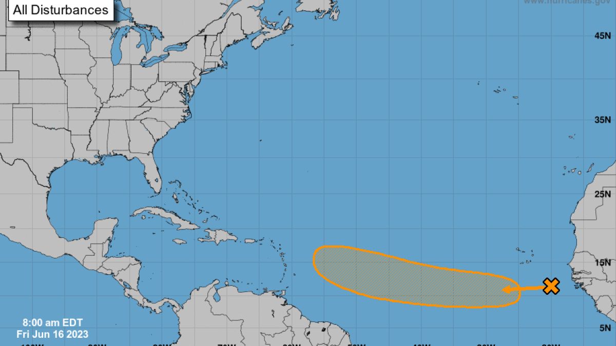
Disturbance in the Atlantic: Favorable conditions for tropical wave to develop
It’s Cape Verde season!
Wait, no it isn’t. It’s mid-June for goodness’ sake! We’re not supposed to be worrying about vigorous tropical waves rolling off the west coast of Africa and past the Cabo Verde archipelago with a chance of developing into tropical storms and hurricanes this early in the year.
And yet, here we are. Welcome to 2023, the year of hurricane season surprises.
Less than one percent of tropical storms on record have formed between Africa and the Caribbean in the month of June — namely “Trinidad” in 1933, “Ana” in 1979, and “Bret” in 2017. Oddly (isn’t everything odd these days?), if this disturbance gets named it too would be named “Bret.”
Get South Florida local news, weather forecasts and entertainment stories to your inbox. Sign up for NBC South Florida newsletters.
I’ve been harping on how off-the-charts hot the sea surface temperatures are in the Atlantic. It is so warm between Africa and the Caribbean now that the current average water temperature of 81.5 °F is the reading normally reached around the peak of the hurricane season on September 1. Tropical cyclones generally need water above 80 degrees to strengthen.
Winds aloft, which typically in June are hostile to fledgling tropical systems, are expected to become tamer as we roll into the upcoming week.
To be able to keep the 2023 Atlantic hurricane season in check despite the heat energy provided by the very warm ocean, we’re going to need to see stronger wind shear. For now, it looks like that inhibiting factor normally provided by the new El Niño phenomenon will be absent for the second half of June in the part of the Atlantic where possible future-Bret could form.
Given these favorable conditions of warm water and little to no wind shear, computer models are confidently forecasting some form of tropical development in that part of the Atlantic basin where we’d normally not be looking at until August.
Seeing reliable global models like the Global Forecast System (GFS) and the European (Euro) in agreement lends further credence to the likelihood of it happening. The National Hurricane Center is already giving the disturbance a medium chance of forming by next week.
National Hurricane Center
If a June tropical storm or—gasp—a hurricane does form in the tropical Atlantic, could it hit the Caribbean, Bahamas, or United States? Thankfully, that seems highly unlikely.
A weaker disturbance in the form of an easterly wave or tropical depression might be able to impact the northeastern Caribbean. But a named storm or hurricane would likely veer north thanks to weaker trade winds and the influence of a dip in the jet stream over the western Atlantic Ocean.
The chance of this system tracking all the way to the Bahamas and the U.S. is close to nil.
John Morales is NBC6's Hurricane Specialist.
Source: NBC 6 South Florida


