Tropical depression, likely to become Bret, forms in Atlantic
Listen 5 min Comment on this story Comment Gift Article Share
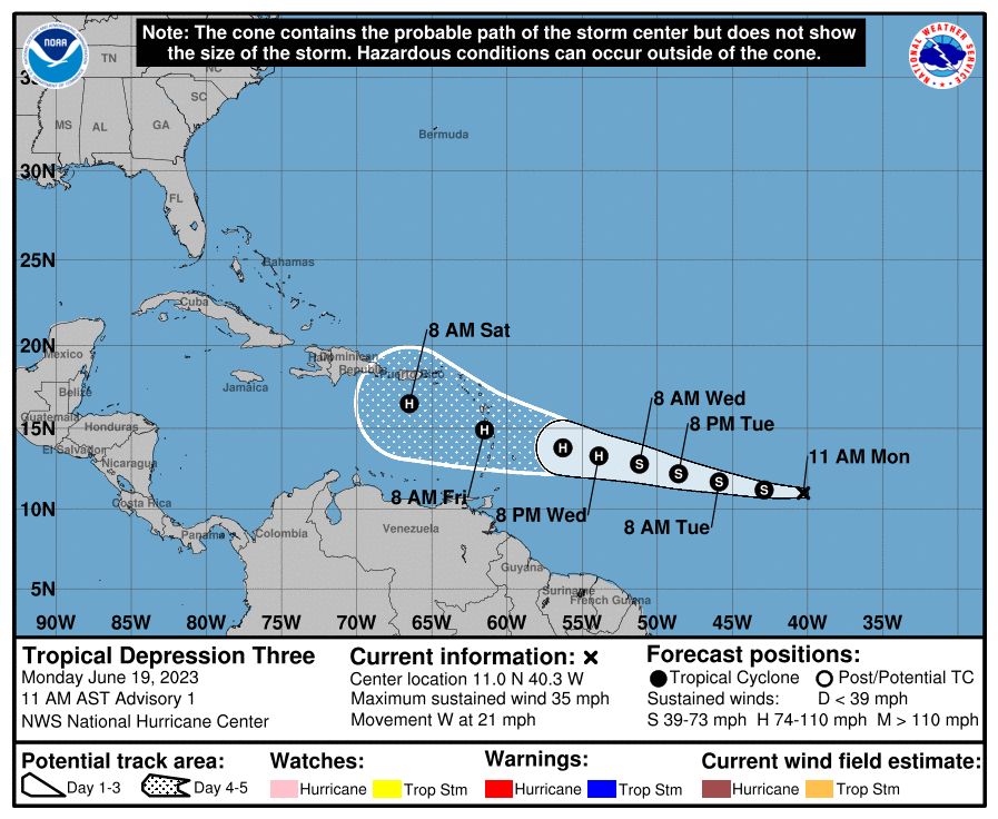
The National Hurricane Center has begun issuing advisories on a newly formed tropical depression — the precursor to a tropical storm — in the Atlantic Ocean currently located about halfway between the coast of Africa and the eastern Caribbean Sea. The system is likely to intensify into Tropical Storm Bret over the next day, and it could approach or impact the Lesser Antilles as a hurricane by the weekend.
“The depression is forecast to strengthen and move across the Lesser Antilles as a hurricane on Thursday and Friday, bringing a risk of flooding from heavy rainfall, hurricane-force winds, and dangerous storm surge and waves,” wrote the National Hurricane Center.
It added, “[E]veryone in the Lesser Antilles, Puerto Rico, and the Virgin Islands should closely monitor updates.” The Lesser Antilles includes the islands of Trinidad and Tobago, Barbados, Saint Lucia and Grenada, among others.
Hurricane season in the Atlantic officially began June 1, but most early-season storms form near the U.S. Eastern Seaboard or in the Gulf of Mexico. So-called “homegrown” systems are typically the result of spin left at the tail end of cold fronts and don’t really amount to much.
Advertisement
What’s happening in the central Atlantic is, at the very least, highly unusual, and may be historic. If the system, dubbed Tropical Depression 3, manages to intensify into a named storm by June 22, it would be among the earliest on record to do so in the Atlantic’s MDR, or Main Development Region. The MDR is the region between the Caribbean and Cabo Verde where long-lived, intense storms can grow out of disturbances rolling off the coast of Africa.
While atmospheric chaos plants the seeds of storm growth, record-warm ocean temperatures over the Atlantic have created an environment ripe for this system’s intensification. Ocean temperatures around the world are at record high levels, with human-caused climate change the driver of a long-term warming trend. The waters in the Atlantic are as warm as they would typically be at the peak of hurricane season two to three months from now.
The Hurricane Center is also monitoring a second disturbance in the wake of this depression that has a strong chance to develop into a storm as well.
The latest
As of midday Monday, the center of Tropical Depression 3 was located more than 1,000 miles west-southeast of Cabo Verde, or 1,425 miles east of the southern Windward Islands, moving west at 21 mph.
Advertisement
Infrared satellite revealed an overnight flare-up in convection, or downpour and thunderstorm activity, associated with the system. On Sunday, it had been a mere skeletal swirl largely devoid of thunderstorms, so the fact that it’s filling in is a harbinger of intensification.
Maximum sustained winds were listed at 35 mph, which is just shy of the 39 mph threshold to be designated as a tropical storm. It is assumed that a cohesive center of circulation exists within the roiling cloud mass, but it’s unclear where exactly that center is located. That makes modeling its future track a bit uncertain.
The nascent storm exhibited healthy outflow, visible in the tendril-like wispy clouds fanning outward to the north. Outflow, or high-altitude exhaust, is integral to strengthening. The more “spent” air a storm can evacuate up and out of its fledgling center, the more warm, humid air from below it can inhale. That fosters further organization and strengthening.
Where Tropical Depression 3 is going
Tropical Depression 3 will be driven west, prevented from turning north in the short term by a blocking zone of high pressure over the central Atlantic. Low amounts of disruptive wind shear, or a change of wind speed/direction with strength, will allow it to intensify, perhaps into a Category 1 hurricane, by Thursday.
Advertisement
If soon-to-be Bret strengthens more quickly than currently predicted, it would grow taller, and would be more prone to a northward curve before the end of the workweek. A taller storm would mimic a sailboat hoisting its sails, catching the wind and being blown in a given direction. However, weather models are more consistent in depicting Tropical Depression 3 as continuing its trek due west, eventually affecting the Leeward Islands.
Heavy rain, strong winds and coastal flooding are likely there Friday into the weekend. Historically, early-season storms are more likely to weaken in the Caribbean, but the unusual circumstances of the present may mean conventional norms don’t apply. The National Hurricane Center projects the system to maintain hurricane intensity into the Caribbean and that its center will be near Puerto Rico on Saturday. However, it cautions that both the track and intensity forecast are more uncertain than normal.
On average, the first Atlantic hurricane doesn’t form until Aug. 11.
How unusual is this?
Simply stated, this is very unusual. There’s a growing likelihood that Tropical Depression 3 will become the tropical storm formed in the farthest-east location on record for the month of June.
Advertisement
Only four other named storms on record have formed in the Main Development Region of the Atlantic during the month of June; the earliest, coincidentally also named Bret, was named on June 18, 2017, but it’s likely this forthcoming rendition of Bret will earn its name farther east.
Exceptionally warm sea surface temperatures, up to 5 degrees above normal, are feeding the storm, and will probably contribute to a number of overachieving systems this hurricane season.
Another storm behind?
Another tropical wave several hundred miles southwest of the Cabo Verde Islands has a 40 percent chance of eventual development. Weather models also forecast this system will strengthen. If it earns a name, it will be called Cindy.
Jason Samenow contributed to this report.
Gift this article Gift Article
Source: The Washington Post


