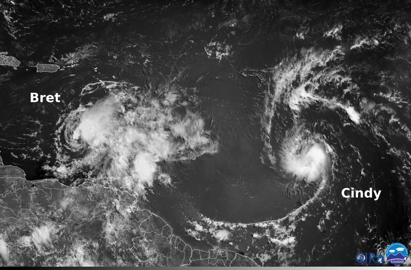
Cindy forms, joining Bret as rare June tropical storm in Atlantic
Listen 4 min Comment on this story Comment Gift Article Share
For the first time on record, two named storms — fueled by record warm waters — have formed in the tropical Atlantic Ocean east of the Caribbean Sea during June. Bret kicked things off this week — developing farther east than any previous tropical storm on record during June. On Thursday night, it barreled across the Lesser Antilles, unleashing damaging winds, heavy rain and massive waves.
As Bret swept across that island chain on the eastern periphery of the Caribbean Sea, Tropical Storm Cindy was born about 1,000 miles behind it.
Both Bret and Cindy formed in the zone east of the Caribbean and west of Africa (south of 23.5 degrees latitude and east of 60 degrees longitude), which is atypical for June. Normally, storms don’t spin up in this area until the peak of Atlantic hurricane season in August or September. But current sea surface temperatures are more characteristic of levels two months from now.
The waters of the tropical Atlantic are generally 4 to 6 degrees (2 to 3 Celsius) warmer than average, while many locations outside the tropics are also abnormally warm.
Advertisement
Scientists blame these warm waters on human-caused climate change, among other factors.
Bret and Cindy mark the first time since 1968 that two named storms are churning across the Atlantic simultaneously in June, according to Philip Klotzbach, a hurricane researcher at Colorado State University.
Cindy is not a threat to land, but Bret caused damage Thursday night as it produced tropical storm conditions in Barbados, St. Lucia, Martinique, and St. Vincent and the Grenadines.
Bret lashes Lesser Antilles
Bret passed quite close to Barbados and St. Vincent late Thursday into the pre-dawn hours Friday. While the storm has since moved into the eastern Caribbean, some stormy weather lingered Friday morning.
The St. Vincent Times wrote that parts of the island had received at least six inches of rain and that a flash flood warning remained in effect early Friday, with up to another 2 to 4 inches possible.
Advertisement
As much as 50 percent of St. Vincent was without power because of multiple failures of high-voltage lines in the wind. A number of houses and businesses were damaged or destroyed, the St. Vincent Times reported.
DISCONTINUATION OF TROPICAL STORM WARNING FOR BARBADOS
The Barbados Meteorological Services (BMS) has DISCONTINUED THE TROPICAL STORM WARNING FOR BARBADOS effective immediately.
This is not an all clear, please follow instructions from the Department of Emergency Management . pic.twitter.com/JPl9b2w8J4 — BarbadosMetServices (@BarbadosMet) June 23, 2023
Similar storm impacts were observed in Barbados, which lies to St. Vincent’s east. Damage on the island included downed trees, scattered flooding and instances of large waves battering the coast, according to Barbados Today.
Services were returning to normal across Barbados early Friday, Barbados Today reported, including flights in and out of Adams International Airport, while schools were closed.
The Hurricane Center reported the Barbados airport clocked a wind gust to 56 mph Thursday night and that a gust to 69 mph was reported at Hewanorra International Airport on St. Lucia. Tropical storm conditions were also observed on Martinique, with gusts up to 50 to 60 mph, the agency said.
Advertisement
Tropical storm watches and warnings that were previously active in the Lesser Antilles were discontinued Friday morning as Bret raced away to the west at 21 mph.
Cindy develops over toasty waters
Tropical Storm Cindy developed about 1,000 miles east of the Lesser Antilles Thursday night.
As of Friday morning, Cindy’s peak winds were up to 50 mph. The storm is forecast to intensify as it passes a safe distance to the northeast of the Caribbean islands this weekend into next week.
Large swells are projected to mostly stay over open waters, although some increase in rip currents and waves is likely along northern beaches of the Caribbean chain.
Bret and Cindy’s future
Side-by-side infrared satellite imagery of TS Bret and TS Cindy the past 24 hours.
Wind shear has been affecting Bret by pushing its strong thunderstorms (deep convection) away from the storm center, while Cindy appears comparatively compact with deep convection near its center. pic.twitter.com/w7ruBtaiYQ — Dr. Kim Wood (@DrKimWood) June 23, 2023
Bret’s intensity has held steady for the past day or so, with peak winds of around 60 mph. However, steady weakening is predicted as it passes through the eastern Caribbean this weekend because of hostile shear, or changing winds with altitude.
Advertisement
“Even stronger shear and a dry mid-level environment are expected to cause Bret to gradually weaken during the next couple of days, with global model fields showing the system degenerating,” the National Hurricane Center wrote. The agency predicts the storm will dissipate by Monday.
Cindy is forecast to suffer a similar fate. Its peak winds are forecast to increase to 65 mph this weekend before it runs into disruptive wind shear and dry air. It’s forecast to gradually dissipate between the Bahamas and Bermuda during the middle of next week.
Gift this article Gift Article
Source: The Washington Post


