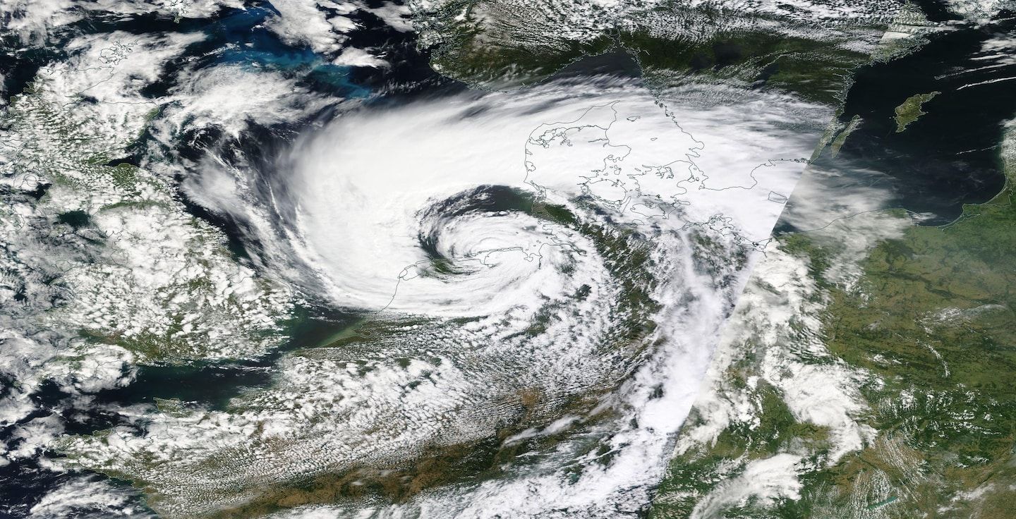
Rare summer storm slamming Western Europe with hurricane-like gusts
Listen 4 min Comment on this story Comment Gift Article Share
An extremely unusual summertime storm is bringing hurricane-strength winds to Western Europe, lashing the Netherlands and Germany and claiming at least two lives according to the Associated Press. The system, which more closely resembles a high-end winter storm, is even producing a destructive “sting jet,” which is mixing jet stream winds to the ground, and causing widespread damage and disruption.
Reuters reported the storm toppled dozens of trees in Amsterdam Wednesday, damaging cars and houseboats and injuring several people. The news agency added that it was the most severe storm on record to strike the Netherlands during the summer months and “its strongest overall since 2018,” according to weather agency Weeronline.
The German Weather Service, which assigned Poly its name, hoisted red warnings for “extreme weather,” the highest on their scale. They were forecasting “hurricane gusts” with winds gusting between 65 and 80 mph out of the south, then switching to the west as the core of Poly swings through.
#StormPoly in the NL
code-red⚠️
Wind force 11 on the Richter scale💨
Intense in my garden🥺 the first fence section has already blown out..😕 #Haarlem👇🏼 (not my town) #storm pic.twitter.com/1gPANXYeOb — Madeleine (@m_ade_lei_ne) July 5, 2023
“Widespread severe damage to buildings is possible,” it wrote. “Trees can be uprooted and roof tiles, branches or objects can fall. Close all windows and doors! Secure items outdoors! In particular, keep your distance from buildings, trees, scaffolding and high-voltage power lines. If possible, avoid staying outside!”
Advertisement
In the Netherlands, conditions are improving after winds gusted as high as 92 mph west of Amsterdam. Winds were settling back into the 40 to 55 mph range as of Wednesday evening local time. Earlier code orange alerts — the highest level issued — have been downgraded to code yellow alerts by the Royal Netherlands Meteorological Institute.
Ijmuiden, the Netherlands, gusted to 92 mph. Nearby Ijmond gusted to 80.4 mph, and Amsterdam to 73.6 mph.
The Associated Press reported that the storm caused hundreds of flights to be canceled or delayed at Amsterdam Airport Schiphol one of Europe’s busiest airports, while halting trains in the northern Netherlands.
What caused Storm Poly?
Poly is a strong low pressure system that evolved out of a broad trough, or southward meandering of the jet stream, on Tuesday. A pocket of high altitude frigid air, low pressure and spin moved overhead to intensify a fledgling surface low over the English Channel. It was pivoted north-northeastward into Belgium, Germany and the Netherlands, and will shift toward Denmark and Sweden on Wednesday night while weakening some.
#StormPoly in the NL
code-red⚠️
Wind force 11 on the Richter scale💨
Intense in my garden🥺 the first fence section has already blown out..😕 #Haarlem👇🏼 (not my town) #storm pic.twitter.com/1gPANXYeOb — Madeleine (@m_ade_lei_ne) July 5, 2023
A broad high pressure system is parked to the east of Poly over Russia. The juxtaposition of the opposite systems created a sharp pressure gradient, or abrupt change in air pressure over a short distance, which was responsible for the strong winds associated with Poly’s arrival.
Advertisement
The presence of fully-leafed trees likely contributed markedly to the damage observed with Poly thus far.
A possible “sting jet”
Here is the radar of rapidly deepening #storm #poly moving onshore into the #Netherlands. This storm has a sting jet feature around the centre of circulation bringing wind gusts in the region of 120-140kph. There is also some heavy rainfall associated with the storm. pic.twitter.com/PFt0ublQHs — Eastern Scotland Wx (@EastScotland_Wx) July 5, 2023
At first glance, it appears that Poly was not a strong enough storm system to create the winds it did simply as the result of air funneling from high pressure to low pressure. It is likely that another mechanism was at play — a sting jet.
Sting jets are narrow corridors of intense wind that form on the “wraparound” portion of a comma-shaped low pressure systems that intensify rapidly.
In the event of a quickly strengthening nontropical system, the jet stream can sweep moisture-laden air into an intrusion of dry air entering the low pressure system. That causes the ice crystals, water droplets and precipitation within that wraparound to quickly evaporate, which results in cooling of the surrounding air. Now suddenly more dense than the surrounding air, that cooled air quickly descends, hitting the ground and bringing jet stream winds with it. String jets can lead to channels of 80 to 100 mph gusts — and occasionally higher.
Advertisement
They are a staple of some of the worst windstorms to ever rake Western Europe. Their existence was postulated following the Great Storm of 1987, which killed 22 people in the highly populous southeast England and adjacent Western Europe. A gust of 135 mph was clocked in Pointe du Roc, Granville, Normandy, France. Winds toppled an estimated 15 million trees, and caused nearly $6 billion in damage.
A later reanalysis of data leading up to the unforecasted windstorm revealed the existence of “sting jets,” which have been observed dozens of times since.
Jason Samenow contributed to this report.
Gift this article Gift Article
Source: The Washington Post


