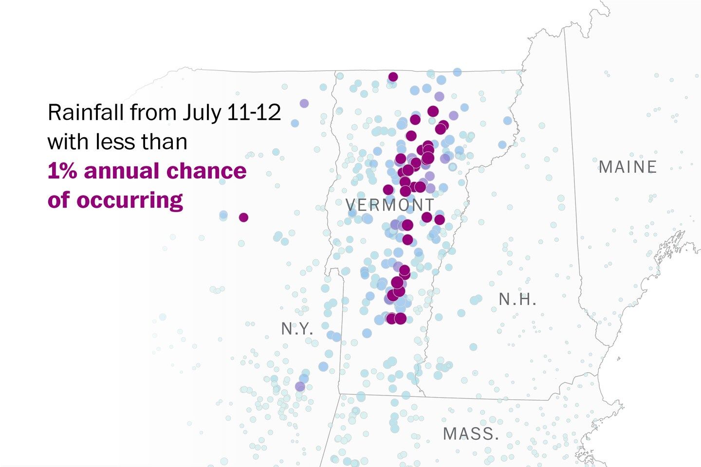
Intense rain that flooded Vermont this week was a 1-in-100-year storm
Climate Lab Why the flooding in Vermont was so unlikely — and why it could happen again 5.27” 5.28” Aug. 28, 2011 Hurricane Irene July 10, 2023 Rainfall with less than 1% annual chance of occurring Rainfall in Montpelier 5 inches/day Less than 2% 4 Less than 10% 3 Less than 50% 2 1 0 2000 2010 2020 Observations from Edward F. Knapp State Airport 5.27” 5.28” Aug. 28, 2011 Hurricane Irene July 10, 2023 Rainfall with less than 1% annual chance of occurring Rainfall in Montpelier 5 inches/day Less than 2% 4 Less than 10% 3 Less than 50% 2 1 0 2000 2010 2020 Observations from Edward F. Knapp State Airport 5.27” 5.28” Aug. 28, 2011 Hurricane Irene July 10, 2023 Rainfall with less than 1% annual chance of occurring Rainfall in Montpelier 5 inches/day Less than 2% 4 Less than 10% 3 Less than 50% 2 1 0 2000 2005 2010 2015 2020 Observations from Edward F. Knapp State Airport
Listen 4 min Comment on this story Comment Gift Article Share
The rainfall that hit parts of Vermont on Monday had less than a 1-in-100 chance of occurring in any given year, according to federal flood data. And yet, for some residents, it brought a sense of déjà vu — it rivaled the devastation of another so-called 100-year storm, Hurricane Irene, from a dozen years ago.
The chances of two such deluges hitting the Green Mountain State in such a short span? Just 0.6 percent, said Art DeGaetano, a professor at Cornell University and director of the National Oceanic and Atmospheric Administration’s Northeast Regional Climate Center.
There was more than chance at play, though, as the planet’s steady warming increases how much moisture the air can hold. Climate scientists have for decades predicted that would translate to extreme bursts of rain in places like New England. While other factors contributed to the floods’ destructive impact — Vermont’s mountainous terrain and preceding weeks of rainy weather — it is a likely sign that those forecasts are becoming reality.
“This, to me, is almost as classic a signal of climate change as warm temperatures,” DeGaetano said. “In a warmer world, this is what you would expect.”
Many of the areas inundated by the storms now face far more serious threats than current federal flood maps suggest, according to new data released by the nonprofit First Street Foundation. In Washington County, where Montpelier is, what was once considered a 1-in-100 year storm is now likely to occur about every 63 years. In nearby Orleans County, such events could happen three times as often as currently estimated by federal flood maps.
The intense and widespread rainfall that occurred from Sunday to Monday had less than a 1 percent chance of occurring in that part of the country, according to NOAA. Widespread rainfall totals exceeding 8 inches were reported from the ski resort town of Ludlow to Montpelier, the state capital.
NOAA estimates the likelihood of extreme rainfall based on past rainfall observations, and doesn’t take climate change into account.
Storm total rainfall July 10 to 11 1” 5” 9” Rainfall with less than 1% annual chance of occurring over 48 hours Less than 2% Less than 10% Less than 50% Cambridge Burlington MAINE Montpelier Waterbury VT. N.H. Ludlow Concord N.Y. Londonderry Albany Boston MASS. Providence Poughkeepsie Hartford R.I. CONN. Bridgeport N.J. New York 50 MILES Note: Map shows preliminary, unofficial precipitation reports Source: Analysis of National Weather Service reports and NOAA Atlas 14 by Jacob Feuerstein and the NOAA Northeast Regional Climate Center at Cornell University Storm total rainfall July 10 to 11 1” 5” 9” Rainfall with less than 1% annual chance of occurring over 48 hours Less than 2% Less than 10% Less than 50% Cambridge Burlington MAINE Montpelier Waterbury VT. N.H. Ludlow Concord N.Y. Londonderry Albany Boston MASS. Providence Hartford Poughkeepsie R.I. CONN. Bridgeport N.J. New York 50 MILES Note: Map shows preliminary, unofficial precipitation reports Source: Analysis of National Weather Service reports and NOAA Atlas 14 by Jacob Feuerstein and the NOAA Northeast Regional Climate Center at Cornell University Storm total rainfall July 10 to 11 1” 5” 9” Rainfall with less than 1% annual chance of occurring over 48 hours Less than 2% Less than 10% Less than 50% MAINE Cambridge Burlington Augusta Montpelier Waterbury VT. Portland N.Y. N.H. Ludlow Concord Londonderry Albany Boston MASS. Providence Hartford Poughkeepsie R.I. CONN. PA. Bridgeport N.J. New York 50 MILES Note: Map shows preliminary, unofficial precipitation reports Source: Analysis of National Weather Service reports and NOAA Atlas 14 by Jacob Feuerstein and the NOAA Northeast Regional Climate Center at Cornell University Trenton Philadelphia
The moisture was wrung from a storm system that remained parked over Vermont for hours, if not days, said Lesley-Ann Dupigny-Giroux, the Vermont state climatologist. While the state’s mountainous terrain always provides lift for rainfall — pushing moisture higher into the atmosphere, cooling and condensing it into precipitation — the weather systems that were steering the storm and slowing its movement were also serving to push the moisture skyward, she said.
And the sheer amount of moisture was unusual. Though the system didn’t start as a tropical storm or hurricane like Irene, it was fueled by a “plume” of moisture wafting in from the Atlantic — similar to the “Pineapple Express” storms that pummeled California with tropical rains this winter. Much of the Atlantic is experiencing record warmth, which means more evaporation to fuel heavier rain.
Advertisement
Places such as Montpelier and Ludlow, where flooding hit hardest, demonstrate why heavy rain can be so devastating in Vermont: all of its steep, rocky slopes send water coursing into river valleys, where people live.
Roads were historically built along streams and rivers because of the terrain, and that means when floodwaters surge, damage to transportation infrastructure can be common and severe, Dupigny-Giroux added.
Montpelier, Vt. Waterbury, Vt. West Point, N.Y. Cambridge, Vt. Ludlow, Vt. Woodbury, Vt. Photos by John Tully for The Washington Post (Woodbury, Vt.); Henrysweatherchannel via Reuters (Ludlow, Vt.); The University of Vermont (Cambridge, Vt., and Waterbury, Vt.); Vermont Agency of Agriculture, Food and Markets via AP (Montpelier, Vt.) and U.S. Military Academy (West Point, N.Y.) Photos were taken on July 10 -11. Montpelier, Vt. Waterbury, Vt. West Point, N.Y. Cambridge, Vt. Ludlow, Vt. Woodbury, Vt. Photos by John Tully for The Washington Post (Woodbury, Vt.); Henrysweatherchannel via Reuters (Ludlow, Vt.); The University of Vermont (Cambridge, Vt., and Waterbury, Vt.); Vermont Agency of Agriculture, Food and Markets via AP (Montpelier, Vt.) and U.S. Military Academy (West Point, N.Y.) Photos were taken on July 10 -11. Montpelier, Vt. Cambridge, Vt. Waterbury, Vt. Ludlow, Vt. West Point, N.Y. Woodbury, Vt. Photos by John Tully for The Washington Post (Woodbury, Vt.); Henrysweatherchannel via Reuters (Ludlow, Vt.); The University of Vermont (Cambridge, Vt., and Waterbury, Vt.); Vermont Agency of Agriculture, Food and Markets via AP (Montpelier, Vt.) and U.S. Military Academy (West Point, N.Y.) Photos were taken on July 10 -11. Montpelier, Vt. Cambridge, Vt. West Point, N.Y. Waterbury, Vt. Ludlow, Vt. Woodbury, Vt. Photos by John Tully for The Washington Post (Woodbury, Vt.); Henrysweatherchannel via Reuters (Ludlow, Vt.); The University of Vermont (Cambridge, Vt., and Waterbury, Vt.); Vermont Agency of Agriculture, Food and Markets via AP (Montpelier, Vt.) and U.S. Military Academy (West Point, N.Y.) Photos were taken on July 10 -11.
Damage was especially severe because, while forests would normally soak up much of the water, that was impossible Monday as the ground was already saturated, said Cameron Wake, a climatologist and director of the Institute for North Atlantic Studies of the University of New England. In many parts of Vermont, even before Monday’s storms, as much as 8 inches of rain had fallen since the last week of June — triple what’s considered normal for that period.
As unlikely and extreme as the floods may seem, they aren’t unexpected to scientists, Wake added.
“If you go back 20 years, what the global climate models were telling us was that we should expect more extreme precipitation events in the future across New England,” he said.
As the floods coincide with extreme heat across the Southwest and repeated bouts of wildfire smoke from Canada, they are showing that intense precipitation isn’t the only climate change prediction scientists say is coming true, Wake said.
“What we’re seeing is the reality happening all in one summer for people in the United States.”
Kevin Crowe and Dan Stillman contributed to this report.
Source: The Washington Post


