Washington could hit 100 for first time in 7 years amid heat wave
Listen 5 min Comment on this story Comment Gift Article Share
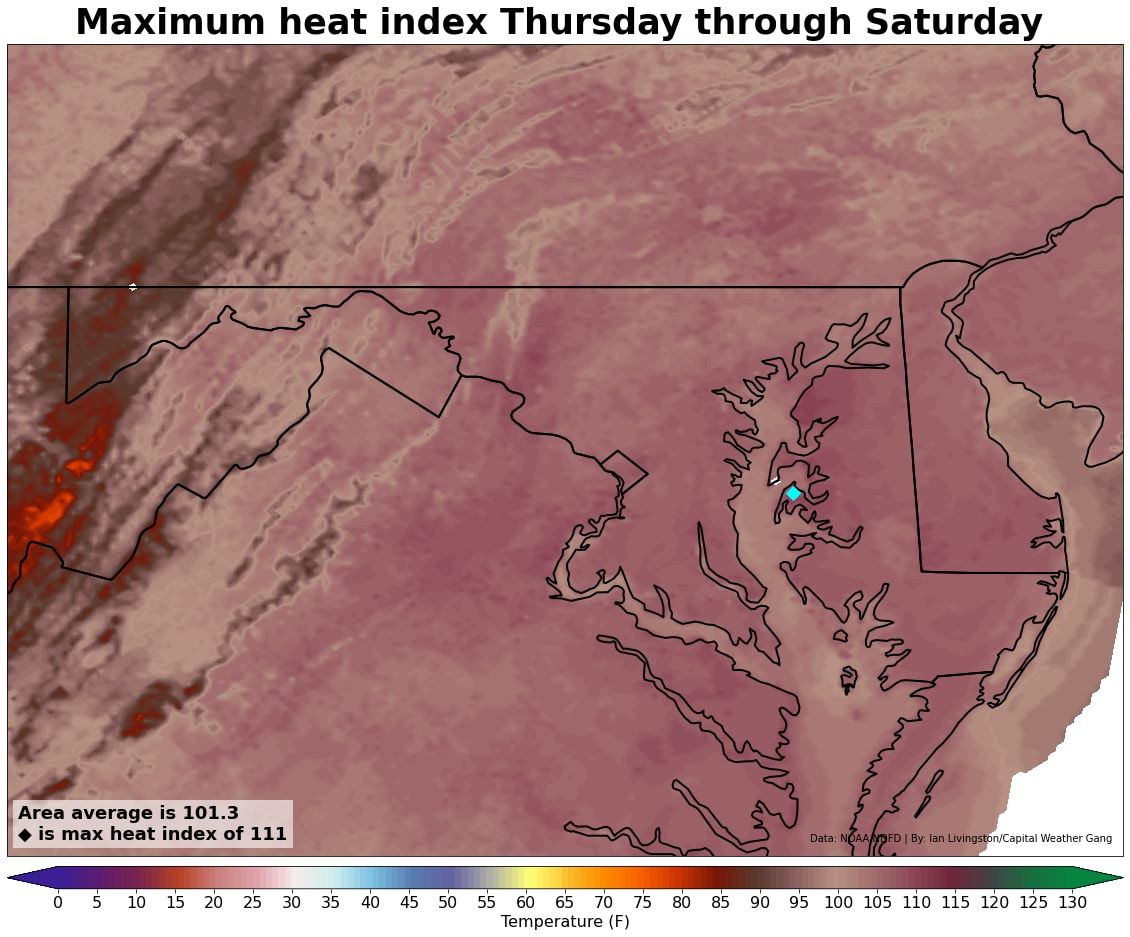
The hottest weather of the summer, and possibly years, is poised to bake the Washington region Thursday through Saturday. Highs could near 100 degrees on all three of those days, and it will feel at least 5 degrees hotter factoring in humidity. Fast, informative and written just for locals. Get The 7 DMV newsletter in your inbox every weekday morning. ArrowRight The National Weather Service has issued a heat advisory for the region on Thursday, when the heat index — or how hot it feels factoring in the humidity — could reach 105 degrees. On Friday, an excessive heat watch is in effect as the heat indexes could approach 110.
“Extreme heat and humidity will significantly increase the potential for heat related illnesses, particularly for those working or participating in outdoor activities,” the Weather Service cautions.
The heat could challenge several calendar day records for both afternoon highs and warm nighttime lows. And there’s a chance Washington could see the air temperature touch the century mark for the first time since Aug. 15, 2016.
Significant relief from the heat is not anticipated until Sunday.
Advertisement
The high temperatures predicted in Washington originate from the same zone of high pressure or “heat dome” that has baked the southern United States in recent weeks. It’s now bulging to the northeast. Record-challenging high temperatures could affect a broad swath of the Mid-Atlantic and Northeast into Saturday.
Temperatures to take a leap on Thursday
The punishing heat is set to burst onto the scene in Washington amid a summer in which temperatures have been rather unremarkable — a little below average in June and a little above average so far this month.
Excessively hot days have been few.
The 16 days at or above 90 degrees so far this year are several days below the norm of 23 to date. But temperatures will catapult on Thursday and remain elevated through Saturday. Upper 90s are forecast by the Weather Service during this stretch and highs could flirt with 100 in a few spots.
Saturday may offer the best chance to reach triple digits unless a cold front, which could trigger some strong thunderstorms, arrives early.
Advertisement
Expect particularly muggy nights throughout the period.
“There will be little relief at night with temperatures only dropping back into the upper 70s in urban areas,” the Weather Service wrote on Wednesday.
Around downtown Washington, low temperatures could hover around 80 degrees. Because of climate change, the number of nights with lows at or above 80 degrees in Washington has increased dramatically in recent decades, but it has been about four years since the last instance.
Records could fall
Calendar day records will be tested in many locations each of the next three days, for both high temperatures and warm low temperatures.
In Washington , the numbers to beat are 100 degrees on Thursday and Friday and 104 on Saturday — the latter a reach. The record warm low temperatures that could be threatened are 81 degrees on Thursday, and 80 on Friday and Saturday.
At Dulles , the standing records are 98 degrees on Thursday, 99 on Friday and 103 degrees (also a reach) on Saturday. Record warm lows in the mid-70s may be at risk all three days.
Missing: 100s
While several recent summers have been hotter than normal, it has been a historically lengthy spell since it last hit at least 100 degrees in Washington.
Not since candidate Donald Trump was running against former secretary of state Hillary Clinton has the city touched the century mark. The triple-digit afternoon reading on Aug. 15, 2016, was part of a three-day streak of 100 degrees or higher that began with 101 on Aug. 13. The heat wave helped that August finish as the second hottest on record in Washington.
Since then, it’s been 2,536 days since it hit 100. This is the longest streak without reaching 100 since a 2,929-day streak that ran from 1969 to 1977.
Advertisement
The ongoing streak is the sixth longest on record in Washington and would move into fifth place in two weeks should it not hit 100 through Saturday. The longest run without 100s since climate records began in 1871 is 4,001 days, from 1887 to 1898.
While it hasn’t hit 100 in Washington during the current seven-year run, it has reached 100 more recently at other locations nearby. Dulles last reached 100 degrees on Aug. 12, 2021, while Baltimore accomplished the feat on July 20, 2020.
A fairly short blast from the furnace
Not long after the extreme heat from the southern and western United States arrives in Washington, it will be preparing to exit. By Sunday, temperatures closer to average for the time of year will return.
Additional bouts of extreme heat are possible during August, but it appears that the center of the sprawling southern U.S. heat dome will migrate westward for a time after its brief visit.
Washington’s average temperatures are also about to begin a decline after their midsummer peak. Highs average 90 degrees for much of July but drop to 89 starting Friday.
Gift this article Gift Article
Source: The Washington Post


