Updates: Severe storms in Loudoun County are heading east
Listen 5 min Comment on this story Comment Gift Article Share
An earlier severe storm in Montgomery County has since weakened but is still bringing rain and rumbles to much of the northern portion of the county. A report of trees and wires down came in from Dickerson, near the Loudoun and Montgomery border.
Storms currently cover much of the area west of a line from Germantown to the Plains in northern Virginia. Heavy rain, frequent lightning and the potential for a damaging wind gust continues in a line from near Leesburg and to the west-southwest to around Middleburg. If these storms continue pushing eastward, they will move into a region from Ashburn to South Riding and perhaps into western Fairfax County over the next hour. Areas along and north of Interstate 66 should monitor their progress. If storms threaten the Beltway region it should be after 7 p.m.
Advertisement
High temperatures today were a record 98 at Dulles, 97 for Baltimore and 96 in Washington while heat indexes climbed as high as 100 to 110 around the region.
4:45 p.m. — Scattered strong to severe storms in western and northwestern suburbs
A powerful storm over northern Loudoun County is moving into southern Frederick and northwestern Montgomery counties. It has been warned by the Weather Service for the potential of damaging winds and quarter size hail. If it holds together, it will move toward Clarksburg and Germantown over the next hour.
Additional activity is attempting to develop in a broken line southwest of there, from near Purcellville to Boyce and Strasburg. If these new cells maintain or expand, they will move into western Loudoun and northern Fauquier counties over the next half hour or so.
Advertisement
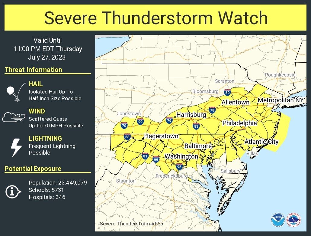
3:45 p.m. — Severe thunderstorm watch issued, in effect until 11 p.m.
Most of the region is now under a severe thunderstorm watch until 11 p.m. A band of storms that has developed in southwest Pennsylvania will head east and southeast over the next several hours. A severe thunderstorm watch means ingredients are in place for severe storms but they are not guaranteed, and that you should stay aware. Then, if a severe thunderstorm warning is issued for your location, you should seek shelter immediately, as it means a storm is imminent or happening.
Storm chances will generally increase as one heads northward into Pennsylvania, and the immediate D.C. metro area is not guaranteed to see much. Any storms that do develop and move through may be intense, however, fueled by the excessive heat. Storms could contain isolated damaging gusts, frequent lightning and heavy rainfall. It is part of a broader risk of severe storms across the northeast United States. More numerous severe storms are ongoing in New England, including one that prompted a tornado report near Keene in southern New Hampshire.
Original article from 2:40 p.m.
We’re still on the edge of the extreme heat overwhelming much of the Lower 48. It should nudge farther in our direction over the next 24 hours, and thus an excessive heat warning has been issued for the area Friday. Persistent clouds this morning helped keep temperatures from reaching their potential today, but most spots were still poised for at least the mid-90s. Tomorrow, we probably won’t be as lucky.
Advertisement
Through tonight: A couple of storms could fire up this afternoon, although the odds seem less than 50/50 of much happening. Any storm that does develop can become intense, with the risk of torrential rain, plentiful lightning and gusty wind. Overnight, partly to mostly clear and sultry. Temperatures are in the mid-70s to around 80 for lows.
View the current weather at The Washington Post.
Tomorrow (Friday): We should see more sunshine throughout the day than today, which means temperatures head even higher. Highs are mainly in the upper 90s to around 100. With dew points in the low 70s, heat index values are around 110 degrees in the immediate area during the afternoon. There’s only a slight chance of a late-day storms.
See David Streit’s forecast through the weekend. And if you haven’t already, join us on Facebook and follow us on Twitter and Instagram. For related traffic news, check out Gridlock.
Record watch: Friday’s records for the major climate stations in the area are below.
Washington: High of 100 in 1997, low of 80 in 1949
Dulles: High of 99 in 1993, low of 75 in 1963
Baltimore: High of 103 in 1941, low of 82 in 1949
Want our 5 a.m. forecast delivered to your email inbox? Subscribe here.
Gift this article Gift Article
Source: The Washington Post


