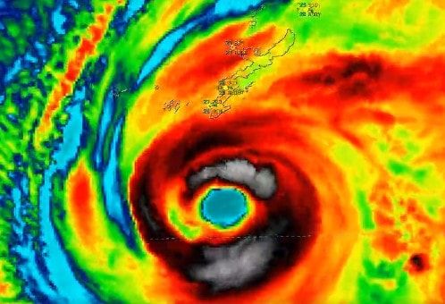
Typhoon Khanun batters Okinawa with destructive winds, severe flooding
Listen 3 min Comment on this story Comment Gift Article Share
Typhoon Khanun was swirling above the East China Sea on Wednesday after battering Okinawa and nearby islands with more than 24 hours of huge waves, ferocious winds and severe flooding, even though the eye of the storm remained offshore. The storm, the second typhoon to affect East Asia in less than a week, left more than 30 people injured, crippled transportation and cut power to approximately 200,000 homes, the Associated Press reported.
Okinawa is Japan’s fifth-largest island, with a population of nearly 1.5 million, and is home to Kadena Air Base, the largest U.S. installation in the Asia-Pacific region.
Hundreds of flights were canceled at Okinawa’s Naha Airport after it endured nearly 30 hours of winds gusting 60 to 100 mph, as the storm reached Category 4 strength south of Naha, in part fueled by record-warm ocean waters. Scenes of wind-swept, torrential rain were common, with widespread flooding reported, including at the air base in Kadena. Wind gusts as high as 105 to 115 mph were recorded, and rainfall totals were expected to reach up to 8 inches across the region.
Still atrocious conditions in southern Okinawa, no let up yet from #typhoon #khanun pic.twitter.com/s1JsOgN8a5 — James Reynolds (@EarthUncutTV) August 2, 2023
“Staff civil and first responders will now fan out to survey damage and establish safe zones,” the Stars and Stripes newspaper reported from Okinawa on Wednesday. “Give the people responsible for clearing away the damage the room they need to do so. It may take some time, given how strong this typhoon is.”
Advertisement
Typhoon Khanun arrived just days after Typhoon Doksuri deluged eastern China with record rainfall, including 29.3 inches in Beijing, the city’s heaviest rainfall in 140 years of record-keeping. That storm was blamed for more than 20 deaths, forced the evacuation of at least 400,000 people in southern Fujian province and knocked out power to more than 1 million homes. The outer bands of Typhoon Khanun could bring more heavy rain to China’s eastern coast in the next few days.
As of Wednesday morning, Typhoon Khanun was approximately 114 nautical miles west of Kadena, tracking to the west-northwest over the East China Sea with estimated peak winds of 115 mph, the equivalent of a Category 3 hurricane. The storm was exhibiting an unusual double-eyewall structure, looking like a small hurricane inside a larger hurricane, with satellite imagery showing a roughly 90 nautical mile-wide “moat” in between. Winds in both eyewalls were estimated at more than 100 mph.
So what happens to the lonely babycane thing inside #Typhoon #KHANUN's huge new eye/moat? Does it float around entertaining itself for a few days? Or does it just fizzle out in a few hours? @EarthUncutTV & I have different takes—but we agree we're sick of these structural freaks. pic.twitter.com/LsF05ixp0t — Josh Morgerman (@iCyclone) August 2, 2023
The storm, while expected to gradually weaken over the next few days, is forecast to make a sharp turn to the north and then east well before the eye would near the eastern coast of China, putting it on a track to potentially affect Okinawa and nearby islands again by Friday and Saturday, with more heavy rain and winds gusts near 80 mph.
The official forecast predicts with “medium confidence” that peak winds will decrease to 80 mph by Friday. Models are less certain about the track forecast, which has a “low confidence” in the three-to-five-day range.
Source: The Washington Post


