Here’s where record heat may envelop the West this weekend
Listen 4 min Comment on this story Comment Gift Article Share
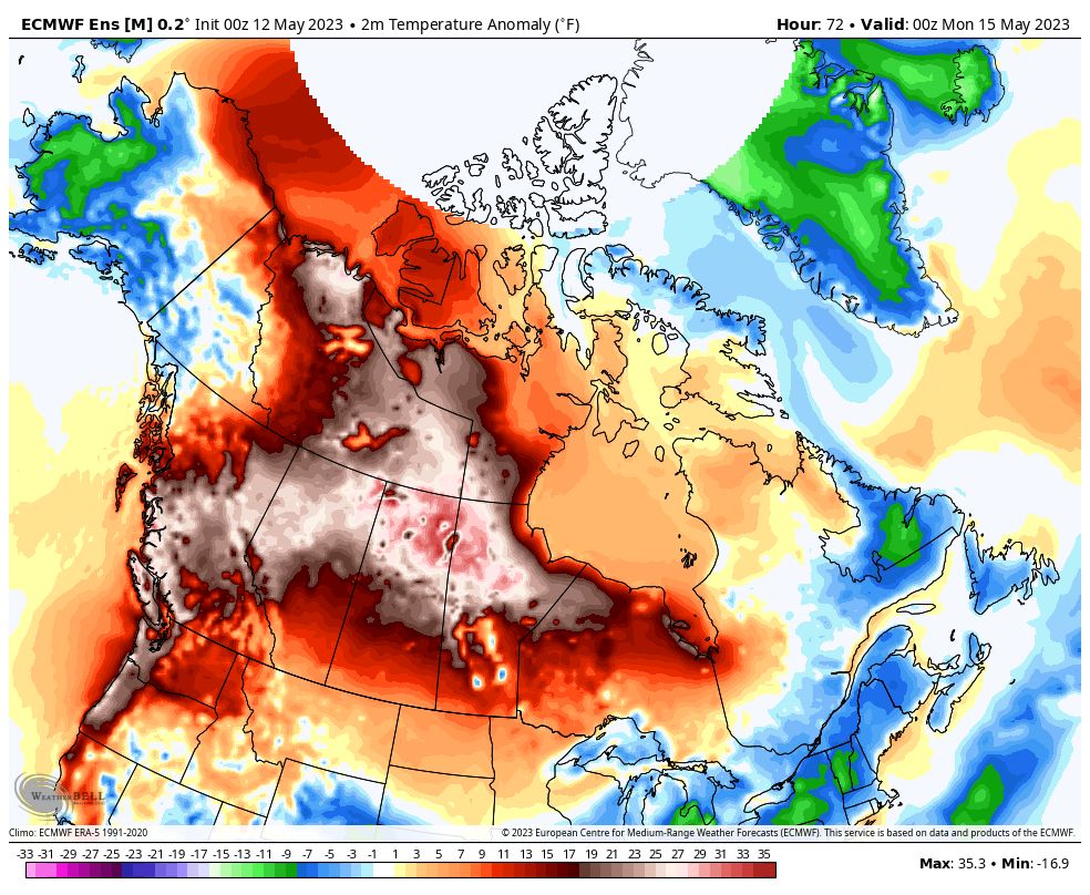
A string of days with record and near-record warmth is unfolding across the Pacific Northwest and southwest Canada, starting Friday then persisting through the weekend and into early next week. Amid the early-season heat wave, temperatures will reach as high as 20 to 35 degrees above normal in a zone from California to the Arctic Circle.
Locations west of the Cascade Range, including Portland and Seattle, have been placed under a heat advisory for the risk of dangerously high temperatures. Readings should top 90 degrees on several days in Portland and could flirt with 90 degrees in Seattle. Heat advisories have also been hoisted for California’s Central Valley, where highs may pop into the 100s on several occasions.
The core of the unusually toasty temperatures ends up north of the international border as a powerful zone of high pressure, also called a heat dome, expands in coming days.
Advertisement
Warmer than average weather has been ongoing in northern Canada for some time now, but this flex begins in Nunavut and the Northwest Territories of the country Friday, where locations on Hudson Bay were already approaching record daily highs. A large area of readings around 35 degrees (20 Celsius) above average is forecast. By Sunday, temperatures 20 to 25 degrees (10 to 20 Celsius) above average stretch from Ontario to British Columbia and southward along the U.S. West Coast.
A similar zone of heat persists through at least Monday before shrinking and weakening somewhat. Despite moderation, many of the same areas can expect above-average temperatures to continue over at least the next several weeks.
Record watch
Widespread temperatures topping 86 to 95 degrees (30 or 35 Celsius) are expected to appear as far north as sub-Arctic locations of northern Alberta. This will threaten temperature records in places such as Fort McMurray, Edmonton and Saskatoon.
Advertisement
The U.S. Pacific Northwest is set to see temperatures upward of 95 degrees to the west of the Cascades, threatening numerous daily high records this weekend and early next week.
In California, the Central Valley will head for the mid-90s to near 100 starting Saturday and lasting into much of next week. These temperatures are as much as 20 to 25 degrees above normal, an anomaly which also stretches into the Pacific Northwest.
Some key records to watch for include:
Seattle is likely to see several daily record highs, beginning as soon as Saturday. A high near 90 degrees on Sunday could threaten the earliest 90 degree or higher temperature on record. The record is May 17 in 2008.
Portland may reach daily records on any day, Friday through Monday, and perhaps all four. Highs there are in the 80s to near 90 degrees Friday and above 90 degrees thereafter.
Vancouver, B.C., could see its earliest 80-degree day on record. The record is May 16 in 2006. The forecast is right around that mark for Sunday and Monday.
Although overnight temperatures are less extreme than they would be in midsummer, dozens of daily record high minimums are likely to be broken across the West, including Southern California and the Rockies, from Saturday through at least late next week.
Temperatures reaching the low 30s across the lower mainland this weekend #bcwx #tasteofsummer pic.twitter.com/m34gqaYOpH — Melinda Singh TWN (@WxMelinda21) May 12, 2023
Fire and (melted) ice
A provincial wildfire emergency is ongoing in Alberta, where more than 400 fires have occurred in recent weeks, dozens continue to burn, and hundreds of troops were recently deployed to help. Blazes in the region have burned more than twice the average to date, according to the Weather Network.
The last few days featured a generally better pattern for firefighters in the region, briefly including cooler conditions and some showers.
Fire concerns will be high in much of Alberta, Saskatchewan, and surrounds as heat builds. Long-term moderate to severe drought across southwest Canada will enhance the heat dome of high pressure by feeding dry air. Air that lacks moisture is easier to heat and also makes for tinder-dry fuels.
Areas of drought are likewise present across much of Oregon and parts of the northern Rockies, where some fire danger will also exist.
Advertisement
Along with high pressure comes tons of sunshine. Since temperatures are set to soar through the weekend and beyond, Weather Service offices are warning of water temperatures that can promote hypothermia in a short period, despite the hot air temperature.
In addition to being cold, rivers and other tributaries in the broader region are running high and swiftly. Snowmelt is likely to accelerate over the next week, including in the Sierra Nevada of California where record snowfall fell over the winter.
GiftOutline Gift Article
Source: The Washington Post


