‘Potentially significant’ El Niño to begin by summer
Story at a glance
El Niño is the warm phase of the climate pattern known as ENSO (El Niño Southern Oscillation).
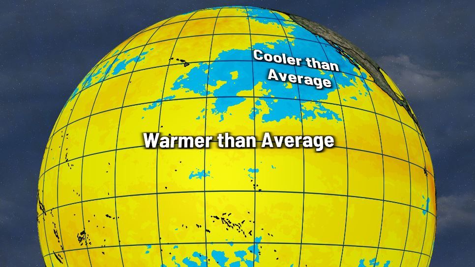
Notable warming of the waters in the eastern equatorial Pacific has further increased the likelihood that El Niño will begin by late spring or early summer.
The odds of El Niño being in place for next winter are now up to 93 percent.
AUSTIN (KXAN) — Notable warming of the waters in the eastern equatorial Pacific has further increased the likelihood that El Niño will begin by late spring or early summer.
The odds of El Niño being in place for next winter are now up to 93 percent.
El Niño is the warm phase of the climate pattern known as ENSO (El Niño Southern Oscillation). For the last three winters we’ve been in the cool phase of ENSO known as La Niña.
As the waters in the eastern equatorial Pacific Ocean got closer to normal we entered an ENSO Neutral phase in March. Now the waters continue to warm to above normal, giving forecasters greater confidence that we’re heading for a prolonged El Niño pattern.
Sea surface temperature anomalies in the Niño regions (CPC/NOAA)
Exactly when El Niño begins will be based on a combination of when the sea-surface temperature anomalies in a specific region of the eastern Pacific Ocean (known as the Niño 3.4 region) reach +0.5ºC and when the atmosphere starts to react like it’s in an El Niño phase.
Computer models predict that will happen between now and July.
The latest forecast from the Climate Prediction Center favors ENSO Neutral (62% chance) in the April-June period with high odds (82%) of El Niño beginning during May-July. The Climate Prediction Center makes its forecast in three-month increments.
ENSO probabilities (May 2023 update)
From then on, El Niño is the dominant ENSO phase through next winter (December 2023-February 2024).
In-Depth: Determining the strength of El Niño
Peeling back the curtain a little bit, we aren’t just concerned about what phase of ENSO we are in, but the strength too. You can have weak, moderate or strong El Niño phases. Typically stronger El Niños bring more impactful weather to parts of the United States, especially for California and the southwest, compared to weaker El Niño phases.
The strength is determined by how much above average the water temperatures are in the Niño 3.4 region.
Water temperatures 0.5ºC above normal = Weak El Niño
Water temperatures 1.0ºC above normal = Moderate El Niño
Water temperatures 1.5ºC above normal = Strong El Niño
Currently, the odds of a moderate El Niño in winter are at 77% with the odds of a strong El Niño at 48% – high odds for something several months away.
The Climate Prediction Center even warned that “a potentially significant El Niño is on the horizon,” after looking at the latest data.
What does El Niño mean for winter?
Assuming we’re in some form of El Niño next winter, that typically means a warmer Pacific Northwest, wetter in the south, southwest and coastal southeast with drier weather in the interior southeast. Cooler weather is also more likely for the south and southeast.
El Niño pattern (NOAA)
The next analysis of ENSO from the Climate Prediction Center will be released June 8.
Copyright 2023 Nexstar Media Inc. All rights reserved. This material may not be published, broadcast, rewritten, or redistributed.
Source: The Hill


